THE striking images of passenger trains under water and trackbed washouts in the Benelux region and neighbouring Germany in the summer of 2021 highlighted how vulnerable rail infrastructure can be to extreme weather. But instead of being rare once-in-a-century events, these major weather incidents are very likely to happen more often, requiring infrastructure managers to make active preparations.
This is not an isolated issue. Australia, Canada, Pakistan, Britain and China have all reported severe damage to their networks caused by flooding in recent months.
The flooding in June 2021 closed railways across Germany, Belgium and the Netherlands as record rainfall in western Europe caused rivers to burst their banks, devastating the region. The German states of Rhineland-Palatinate and North Rhine-Westphalia and the Belgian provinces of Namur, Luxembourg and Liège were worst hit. German infrastructure manager DB Network reported that flooding damaged more than 600km of track and 80 stations as well as lineside equipment and signalling, with some trains submerged by floodwater.
Belgium
In Belgium, the network was closed between Charleroi, Namur and Liège, and down to Arlon near the border with Luxembourg. Services on the cross-border Sittard - Maastricht - Liège route between the Netherlands and Belgium were cancelled.
Belgian infrastructure manager Infrabel says the flooding was caused by a “water bomb” with 270mm of rain falling in just 48 hours. This followed two months of extremely wet weather. The hilly topography of southern Belgium combined with the level of saturation caused what was considered a once in 300-year flood that killed 39 people, with 50,000 homes submerged, 11,000 vehicles washed away, and 160,000 tonnes of waste produced by the deluge. The cost of the damage was estimated at €3-4bn.
At the height of the flooding, half of the Belgian rail network was inoperable, with the south predominantly affected, including the three European freight corridors that run through the country.
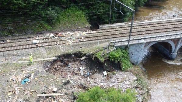
Overall, there were 25 impacted zones on the network, with 3km of track and 2km of overhead line needing to be rebuilt. Two bridges collapsed, while the embankments at another four were washed out. The disaster cost Infrabel more than €65m, of which a significant section will be pre-financed by the federal government before being covered by the insurers.
“We have been warned and we must prepare for things like that, and not only anticipate that this might happen in the south but this could also happen in the north.”
Bart Kamoen
Within two weeks, Infrabel had repaired and reopened the main lines, with some branch lines reopening a month and a half after the flooding. By the start of the school year at the beginning of September, six weeks after the flooding, only three of the 25 closed rail lines were still impassable.
The flooding was unlike anything the rail network had experienced, says Infrabel civil engineering expert, Mr Bart Kamoen, with the biggest impact on the riverbeds running alongside and beneath the rail network which caused slope instability, impacting the integrity of embankments beneath the railway.
“The bridges were built in the late 19th century, and we can say we never had any embankment problems in the region since the bridges were built,” Kamoen says. “So it was really a very unique situation.”
The repair work initially focused on tasks that could be completed relatively quickly, such as replacing ballast and reinstating track and overhead lines. 2000 sleepers and 100,000 tonnes of ballast were replaced, while work continued on more time-consuming repairs such as the rebuilding of bridges and embankments.
Infrabel used filler beams to accelerate bridge replacement, with these rebuilt in the same places as the previous structures to limit the time required to reopen the lines.
“It was important that we rebuilt the bridges as they were, so we didn’t change the tracks or change the abutments, which would take much more time,” Kamoen says. “Our objective was really to put the track back as quickly as possible.”
However, this means the bridges could be susceptible to a repeat of the 2021 flooding. Infrabel is studying whether it will need to increase the space beneath the bridges across its network with this work already resulting in the rebuilding of one bridge.
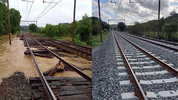
25 closed rail lines were still impassable. Photos: Infrabel
“We have been warned and we must prepare for things like that, and not only anticipate that this might happen in the south but this could also happen in the north,” Kamoen says.
To repair and stabilise the affected embankments, Infrabel began using large slabs of limestone quarried directly for the infrastructure manager due to the quantity of material required.
An inventory of the embankments is currently being undertaken and is due to be completed in March, with a risk analysis to determine which measures are needed for each embankment expected to take another three to four months.
Infrabel is also reviewing how it designs and manages additional infrastructure such as drainage. This includes adapting the technical design requirements for the dimensioning and the stability of foundations of drainage infrastructure to new meteorological data on a 100-year rainfall or a 1000-year rainfall.
“That means that the new drainage infrastructure will need to be able to cope with water quantities related to very short, intense rainfall, but at the same time, we also know that the rainfall in winter is likely to increase and maybe [happen] over a longer period of time,” says Infrabel climate change advisor, Ms Patricia Grobben. “That drainage infrastructure should also be able to cope with long periods of rainfall [with high sediment flows].”
Instead of attempting to undertake all the studies that are required to determine how future weather events will affect its network, Infrabel is using work already being undertaken by third parties, such as climate projections by the Belgian Meteorological Institute and the flood risk analyses in future climate scenarios undertaken by regional authorities.
New technology will also play a part in preparing the network for future high rainfall events. Infrabel is experimenting with installing internet-connected sensors in tunnels to measure water levels, as well as working with external parties already studying flood risks using digital sensors.
Wales
Similar to southern Belgium, Wales’ hilly terrain also makes it susceptible to flooding events, with railways traditionally built along the flatter valleys as this was cheaper and easier.
The Cambrian Line was last damaged by flooding in 1994, in what was then considered a once in 150-year event. However, it was closed for several weeks between Welshpool and Newtown in February following three back-to-back storms that caused the River Severn to breach its banks. The water rose 3.9m above the normal level - just 9cm lower than the highest level on record.
While it was initially thought that this had caused 12 areas of ballast to be washed away, further investigation by infrastructure manager Network Rail and AmcoGiffen engineers revealed 33 severely impacted sites along an 800m section of railway.
Extensive repair work included the removal of 3000 tonnes of debris, laying 4000 tonnes of new ballast, three tamping shifts to realign and level the track, replacement of 800m of double track, planting new hedgerows, clearing 11 culverts and installing new fencing and telecoms cables.
The washouts occurring on the Cambrian Line echo problems seen at Conwy, between Llandudno Junction and Blaenau Ffestiniog, and Vineyards, between Abergavenny and Hereford, with these issues becoming more common, explains NR senior network delivery manager for the Wales Route, Mr Chris Howchin.
The three locations are similar, with a river running beneath the railway before turning to run parallel to the line as it continues downstream. During the flooding events, the water has been unable to pass under the railway bridge and has instead overflowed onto surrounding farmland. It then tries to do “pretty much what water always does, to try and find its easiest route through” which in these cases has been over the railway.
A washout is caused when the water permeates through the trackbed and begins to scour out the ballast, a process that accelerates as more water washes away more ballast. “Once it’s found its little route through, it is like getting the thin end of the wedge in and it will just make it worse and worse,” Howchin says.
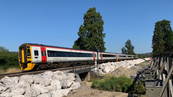
NR worked with hydromorphologists and determined that it was more important to slow the rate of the water flow than to allow the water to move through at speed. This resulted in the development of “rock armour” installed alongside the track.
The rock armour is formed of varying sized boulders, ranging in size from one to five tonnes, with smaller infill rocks between them. The science behind the technology has been around for a number of years, Howchin says, but hasn’t previously been used due to its high cost and the availability of other methods, such as the use of culverts.
“When the computer flood modelling was done to look at what is essentially a 19th century infrastructure being impacted by a 21st century problem, [we realised] we’ve got to think differently, we can’t just put in that 19th century solution of another culvert or another bridge - there has to be something a lot more robust,” he says.
“You could put in the culverts to allow some equilibrium with the water pressure from one side to the other, formalising that difference in pressure. However, there were still areas where it wanted to go. Water, being a bit like electricity, is trying to find its easiest route through, so those culverts would only do so much and what was found is that the rock armour needed to be put into place.”
Instead of being installed on the “high” side of the line, where flood water accumulates prior to flooding the railway, the rock amour is installed on the “low” side, where the water is flowing through, to reduce the velocity of the water.
“You think of rock armour as preventing penetration, but actually it’s the reverse … it’s actually keeping a retention to the ballast,” Howchin says. “You’re not trying to prevent the water going through, you’re trying to prevent it washing out. There may be little pockets of scouring, but they’ll be easy to repair within hours rather than weeks.”
The system was first trialled at Conway, before being installed at the other two sites.
“[Welshpool has] culverts that will go through that location, but they just weren’t able to alleviate the pressure,” Howchin says. “So there were considerable washouts over a six-month period, with repair costs of around £1.5m. Now, because that was going to be a continual risk, it was better to invest around £4m to do the rock armour works than to go back every time plus all the delays to passengers or the disruption.”
This is becoming more important as flooding events happen at more frequent intervals. Howchin points to flood damage in Gloucestershire in 2007, when heavy rain severely damaged the Cotswold Line between Evesham and Oxford.
“We looked at that as being a one in 100-year flood,” he says. “Since 2019 on the Wales Route, with Conway, Vineyards and Welshpool, we’ve realised that this isn’t going to go away. This is a sign of climate change, and we’ve got to consider this isn’t a one in a 100-year flood problem, now this could be a one in 20 or one in 10 year [problem].”
In light of this, Network Rail and other infrastructure managers are now looking to identify which areas are more prone to flooding or washouts, and proactively prepare flood defences in these areas. This includes prioritising which areas are more at risk.
“The issue is that if everything’s a priority, then nothing’s a priority,” Howchin says. “If we tried to make everything resilient, we would break the exchequer tomorrow.”
NTSB calls for improved weather monitoring
THE United States National Transportation Safety Board (NTSB) has issued a safety recommendation to the North American Class 1 railways and the American Short Line and Regional Railroad Association (ASLRRA) highlighting the importance of maintaining dynamic weather alert criteria in rail operations. This follows a derailment on the CSX Transportation network on February 13 2020 that resulted in the release of hazardous materials.
This was not an isolated incident, with NTSB investigating five other derailments in the past 40 years where adverse weather conditions, particularly rainfall, affected railway infrastructure and created unsafe operating conditions.
that covered the tracks.
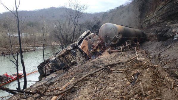
The derailment on the CSX network at Draffin, Kentucky, followed heavy rainfall. However, an investigation found that the weather alert criteria did not account for the potential risks from excessive rainfall in the days, weeks or months before the accident.
The high-hazard train carrying flammable denatured ethanol derailed between a hillside and the Russell Fork River near Draffin. In the two weeks before the derailment, the area received more than 300% of its normal amount of rainfall, while 500-750% of normal precipitation fell in the week before the derailment. This excessive rainfall led to a landslide that covered the track with mud and debris immediately before the derailment.
The NTSB investigation found that the weather alert criteria used by most Class 1 railways and some major short line railways are based on “static criteria,” meaning they only consider the current weather and near-term forecast and not unusual weather conditions in the days preceding the alert. For example, CSX’s static criterion for a flash flood alert was at least 76mm of rain over a period of three hours or less. The criterion did not consider the effects of accumulated rainfall during the previous two weeks.