RECENT changes in precipitation patterns due to climate change have left many railways vulnerable to the risks posed by unstable embankments. Multiple landslides in Austria, Norway, Russia and the United States in 2023 resulted in the closure of numerous lines previously unaffected by such events and highlighted the risks that railways increasingly face.
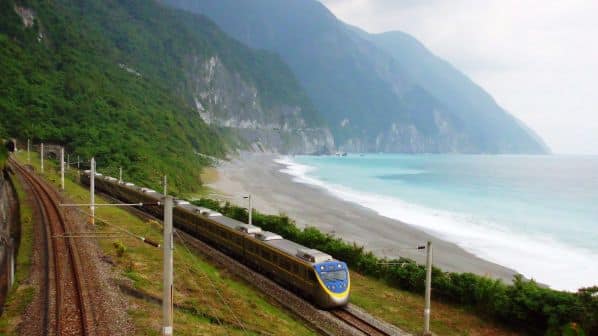
Taiwan’s frequent encounters with earthquakes and heavy rainfall seasons have made railway embankment failures a long-standing concern.
Taiwan is situated on the edge of the Pacific Ring of Fire. The island boasts unique and young geological characteristics, which are often unstable and susceptible to earthquakes and other activity, leading to ground movement and changes in terrain.
These adverse geological conditions present severe hurdles to constructing and maintaining Taiwan’s railway network, which is already challenged by the country’s mountainous terrain. Railways have been built along these winding slopes and traverse the rugged terrain. This demands highly precise engineering design and continuous monitoring and maintenance to prevent landslides or other incidents caused by geological instability from impacting rail operations.
Engineers have employed various innovative technologies to overcome these natural obstacles, which include earthquakes, ground subsidence and landslides. However, geological changes are ongoing, and together with the impact of climate change, altered rainfall patterns will continue to affect railway operations and maintenance.
To address these related risks, the Industrial Technology Research Institute (ITRI) developed an early inspection system designed to continuously monitor and evaluate slope safety conditions on railways. This technology is an engineering breakthrough and an effective response to Taiwan’s unique geological and climate challenges.
Electrical Resistivity Tomography
Electrical Resistivity Tomography (ERT) is a conventional geophysics exploration technology primarily used to infer resistivity distribution beneath the Earth’s surface. This method involves placing a series of electrodes on the ground and applying electrical current between them. The variations in measured potential differences are used to estimate the resistivity at different depths and locations underground. The resulting data can then be used to construct two or three-dimensional images of subsurface structures, providing detailed information about subterranean rock, soil and hydrological conditions.
The Green Energy and Environment Research Laboratory of ITRI advanced traditional ERT with the introduction of High-density Multi-temporal Electrical Resistance Detection (HM-ERT) technology. This improvement primarily involves substantially enhancing the detection instrument co-developed with National Central University. Compared with traditional instruments, HM-ERT is a multi-channel measurement system that continuously measures potential difference and current, storing all recorded data as time-series information, ensuring high data transparency and facilitating further analysis. Additionally, the instrument can be remotely monitored and scheduled. HM-ERT saves substantial field investigation and analysis time in the long term.
Once the monitoring system has been set up, data can be continuously collected without frequent field surveys, significantly reducing the time and workforce required for field investigation. Moreover, HM-ERT is no longer limited to traditional fixed electrode arrangements. Users can customise any four-electrode array, significantly increasing detection flexibility and data volume.
Continuous detection
HM-ERT provides high-density data in a single detection and aids problem analysis. The procedure can be helpful in differentiating between resistivity profiles; for example, mudstone and water-bearing sandstone might exhibit similar low resistivity characteristics in single-survey results. Each type of stratum requires different engineering remediation strategies. Since groundwater distribution and flow are dynamic, a single survey cannot fully capture the complete behaviour pattern of groundwater. Continuous detection at different time points and analysing changes in layer resistance, however, can more accurately portray underground geological structures and groundwater distribution.
Multi-temporal detection provides more information for understanding geological materials and plays a vital role in data quality control. For instance, as shown in Figure 1, continuous potential difference changes measured with the same electrodes at different times reveal additional potential noise when a train passes the measurement area (Figure 1a).
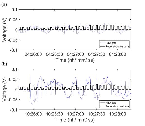
In contrast, in the absence of train movement (Figure 1b), the signal forms a complete square wave after digital signal processing (Figure 1b black line). Thus, continuous multi-temporal detection can evaluate the optimal detection period to avoid geological interpretation errors caused by noise in the analysis data. Continuous recorded potential difference data can also undergo advanced processing to remove noise, ensuring more reliable data.
By utilising HM-ERT detection, we can significantly enhance the precision of assessing the stability of railway slopes. This advanced technology can reveal the patterns and distribution of groundwater flow, which is crucial for a deeper understanding of slope stability.
The movement and pressure changes of groundwater can significantly impact slope stability. Understanding these hydrological flow patterns allows for a more accurate assessment of the impact of slope reinforcement or other engineering activities on slope stability, ensuring accurate and safe execution of these projects. Moreover, in the face of natural disasters such as earthquakes or heavy rainfall, electrical resistance monitoring can rapidly evaluate the extent of damage and stability of slopes, facilitating prompt emergency response measures. Most importantly, long-term data accumulation can establish a comprehensive underground database to detect early signs of slope instability, such as abnormal rises in groundwater levels or unusual changes in soil moisture content. These early warnings enable timely preventative measures, effectively reducing the risk of landslides or collapses that could jeopardise railway safety.
Rollout in Taiwan
HM-ERT has been successfully installed at multiple sites in Taiwan, covering the young geological conditions of the western side of the island and the steep, landslide-prone slopes of the east.
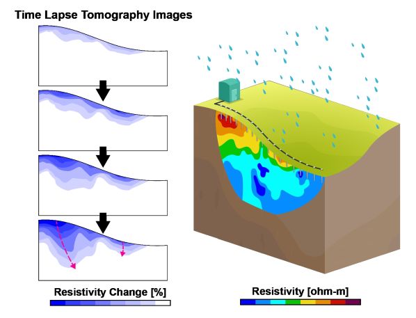
Using this technology, we have conducted continuous observation and effectively analysed the dynamic changes in water flow in the slopes of these regions. Figure 2, right, illustrates the analysis process, where a single ERT measurement provides a snapshot of the distribution of geological materials at a specific time. We can interpret the dynamic behaviour in water flow by monitoring various time points and comparing the analysis with background values (Figure 2, left). Two case studies highlight how the technology works in practice.
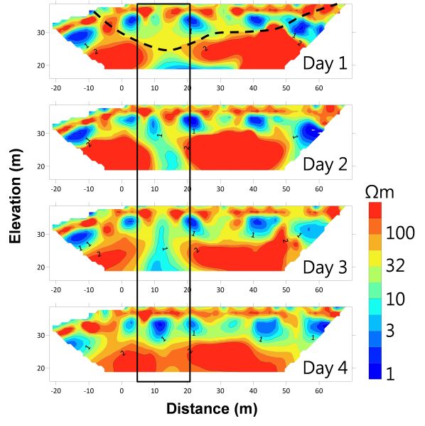
In Tongxiao Township, Miaoli county, a railway embankment has long suffered subsidence issues. After implementing HM-ERT, we obtained a series of valuable data. Figure 3 shows the results of a four-day survey, with rainfall on the second day causing noticeable changes. A low-resistivity phenomenon was observed within the black-framed area, which disappeared on the third day as the weather cleared and the resistivity values returned to their original dry state. This phenomenon matches the trend of surface subsidence (black dashed line), indicating that this area is a major pathway for water flow and may lead to soil variability and subsidence in the region. This provides clear guidance for subsequent remediation work.
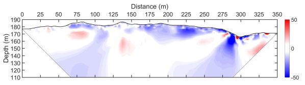
In Wanrong Township, Hualien county, where a slope is about 150m from the railway, past simulations have shown that a landslide could completely cover the railway, with severe consequences. We applied HM-ERT to this slope to identify water flow paths and determine the optimal placement of drainage pipes. Figure 4 shows a differential analysis before and after heavy rainfall. The blue areas indicate the range of decreased resistivity, showing that shallow layer resistivity decreases due to increased moisture content in the rock layers. These areas of decreased resistivity often occur at convergence points in topographic depressions, which are the main infiltration points and potential water accumulation areas. This case accurately identified these critical locations and determined the direction of water flow in the landslide area as well as the appropriate placement for drainage pipe installation, leading to effective drainage works and, thus, ultimately preventing landslides.
These two cases demonstrate how HM-ERT can visually pinpoint areas requiring engineering remediation, enhance detection speed, resolution, and analytical capabilities, and provide a basis for preventative treatment and enhanced railway safety.
Through persistent efforts, HM-ERT has shown increasing potential for broader applications in Taiwan. It is expanding its reach beyond the current nine locations. ITRI is currently engaging with the Eastern Railway, an area prone to landslides, and implementing HM-ERT on sections of the Western High-Speed Railway. These projects aim to enhance safety in critical areas further, and they underscore the value of HM-ERT, which is available to infrastructure managers in other regions worldwide.
Beyond focusing on early detection and using collected data for engineering remediation, ITRI continues to advance HM-ERT by applying additional automated equipment and sophisticated analytical systems to achieve more precise infrastructure monitoring. Currently, AIoT devices are being integrated to understand anomalies of surroundings better. These endeavors reflect ITRI’s dedication to reducing the risks to safe rail operations posed by unforeseen natural disasters.